 pyModis
modis_convert.py
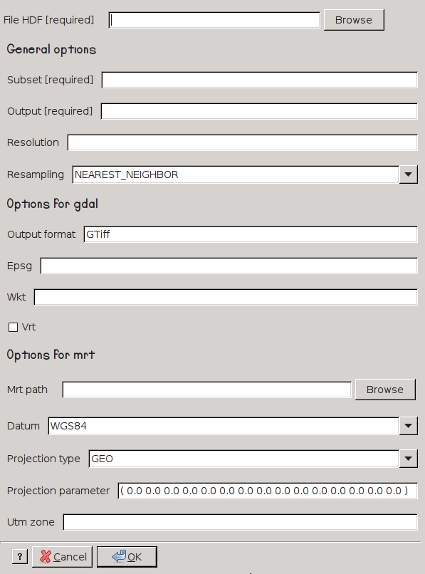
modis_convert.py converts MODIS data to TIF formats and different projection reference system. It is an interface to MRT mrtmosaic software or GDAL library.
Usage
modis_convert.py [options] hdf_file
Options
-h, --help            show this help message and exit

Required options:
  -s SUBSET, --subset=SUBSET
                      (Required) a subset of product's layers. The string
                      should be similar to: ( 1 0 )
  -o OUTPUT_FILE, --output=OUTPUT_FILE
                      (Required) the prefix of output file
  -g RESOLUTION, --grain=RESOLUTION
                      the spatial resolution of output file
  -r RESAMPLING_TYPE, --resampl=RESAMPLING_TYPE
                      the method of resampling. -- mrt methods:
                      'NEAREST_NEIGHBOR', 'BICUBIC', 'CUBIC_CONVOLUTION',
                      'NONE' -- gdal methods: 'AVERAGE', 'BILINEAR',
                      'CUBIC', 'CUBIC_SPLINE', 'LANCZOS', 'MODE',
                      'NEAREST_NEIGHBOR' [default=NEAREST_NEIGHBOR]

Options for GDAL:
  -f OUTPUT_FORMAT, --output-format=OUTPUT_FORMAT
                      output format supported by GDAL [default=GTiff]
  -e EPSG, --epsg=EPSG
                      EPSG code for the output
  -w WKT, --wkt_file=WKT
                      file or string containing projection definition in WKT
                      format
  -v, --vrt           Read from a GDAL VRT file.
  --formats           print supported GDAL formats

Options for MRT:
  -m MRT_PATH, --mrt=MRT_PATH
                      the path to MRT software
  -d DATUM, --datum=DATUM
                      the code of datum. Available: 'NODATUM', 'NAD27',
                      'NAD83', 'WGS66', 'WGS72', 'WGS84' [default=WGS84]
  -t PROJECTION_SYSTEM, --proj_type=PROJECTION_SYSTEM
                      the output projection system. Available: 'AEA', 'GEO',
                      'HAM', 'IGH', 'ISIN', 'LA', 'LCC', 'MOL', 'PS', 'SIN',
                      'TM', 'UTM', 'MERCAT' [default=GEO]
  -p PROJECTION_PARAMETERS, --proj_parameters=PROJECTION_PARAMETERS
                      a list of projection parameters, for more info check
                      the 'Appendix C' of MODIS reprojection tool user's
                      manual https://lpdaac.usgs.gov/content/download/4831/2
                      2895/file/mrt41_usermanual_032811.pdf [default=( 0.0
                      0.0 0.0 0.0 0.0 0.0 0.0 0.0 0.0 0.0 0.0 0.0 0.0 0.0
                      0.0 )]
  -u UTM_ZONE, --utm=UTM_ZONE
                      the UTM zone if projection system is UTM
            the UTM zone if projection system is UTM
Examples
Warning
The resolution value in modis_convert.py has to be set with the
right value depending on the projection used. 1 kilometer in metrical
projection has to be set as 1000 meter, instead in latitude and longitude
something like 0.01* depending on the placement in the Earth.
MODIS Reprojection Tools
Warning
You can find the supported projections in the ‘Appendix C’ of
MODIS reprojection tool user’s manual and the datums at section
Datum Conversion of the same manual
Convert layers from MODIS data with the original resolution in latitude and longitude reference system
modis_convert.py -s "( 1 0 1 0 )" -o OUTPUT_FILE -m "/usr/local/bin/" FILE
Convert layers from MODIS data with output resolution in 500 meters with UTM projection in the 32 zone
modis_convert.py -s "( 1 0 1 0 )" -o OUTPUT_FILE -m "/usr/local/bin/" -g 500 -p UTM -u 32 FILE
GDAL
Convert the first layer in latitude and longitude with the original resolution
modis_convert.py -s "( 1 )" -o OUTPUT_FILE -e 4326 FILE
Convert the first three layers from MODIS data with output resolution in 500 meters with UTM projection in the 32 zone
modis_convert.py -s "( 1 1 1 )" -o OUTPUT_FILE -g 500 -e 32632 FILE